Late Season Tornado Rips Through Dallas
October 21, 2019 - HailWATCHLate Season Tornado Rips Through Dallas, TX
Dallas, TX – On October 20, 2019 at around 9:00 pm, severe storms moving through north Texas spawned at least one tornado that ripped up trees, homes and businesses and reportedly threw debris 20,000 feet into the air. Amazingly, no deaths have been reported from the twister, likely because appropriate warnings were issued and residents took cover.
To set the stage meteorologically, a large trough and associated jet stream made its way onto the West Coast to end the week and then pushed east as the base of the trough moved into west Texas on Sunday, October 20th. This setup certainly provided the power to produce tornadoes and large hail, which both occurred on the night of the 20th. The following is the Sunday morning forecast model for around the time of the tornado later that night. Combine the jet stream configuration on the left with plenty of moisture at the surface levels on the right, and you have the ingredients for severe storms across the region, which certainly kicked into action as night fell on the Dallas-Ft. Worth Metroplex.
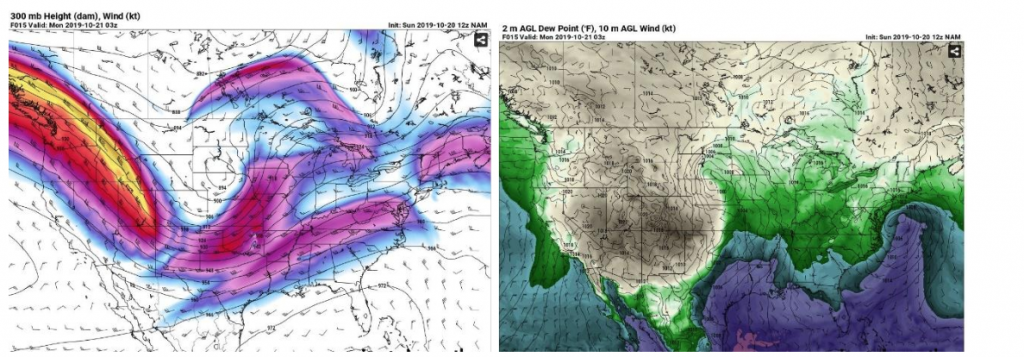
Image 1: 300mb Jet Stream configuration around 9:00pm, October 20, 2019
Image 2: Surface dew points around 9:00pm
As the storms began building, the initial cells produced large hail west and north of the tornado drop-zone. Those storms did not drop any tornadoes, but produced golf ball- to baseball-sized hail. Here is the map showing the distribution of hail around the region. The preliminary path of the tornado is shown below as well.
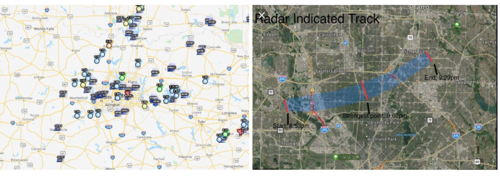
Image 3: Local storm reports after the event.
Image 4: The preliminary tornado path on October 20, 2019
Although there were plenty of storms around the area, one cell focused the energy and dropped the tornado. You can see from a screen grab of the reflectivity on the left below, the hook echo formed just north of University Park, where the worst damage was reported. The image to the right shows the Base Velocity at the same time. This shows air moving TO and FROM the radar, so when you have green right next to red, specifically when the green is surrounded by red, the air is rotating in that spot, strongly.
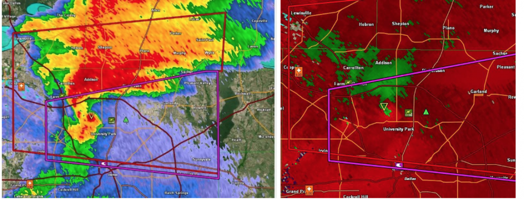
Image 5: Doppler radar image taken just after 9:00pm showing hook echo.
Image 6: Base Velocity snapshot from Doppler Radar just after 9:00pm.
October is not what most people consider as the prime time of year for tornadoes, but believe it or not, this is a secondary storm season as the jet stream makes its way back south with winter setting in. The typical storm season is in the spring for Dallas, which is when the jet stream is retreating back north as summer begins to make itself known. Then, we see the heat of the summer from June-August as the jet stream is well to the north dropping hail and tornadoes in the Dakotas and Canada. So, as it retreats back south, we can get a secondary storm season around October – which is certainly proving to be true in 2019!
The tornado moved from the southwest to the northeast ahead of a strong cold front. The extent of the damage from this tornado is still in the process of being investigated, but the fact that no lives were lost is a testament to the NWS and getting the warnings out into the public. More than 112,000 customers were without power Monday morning and many flights were delayed or cancelled due to the close proximity of Love Field and DFW airport. In the end, this could have been much worse and everyone is thankful for the limited injuries and zero deaths.