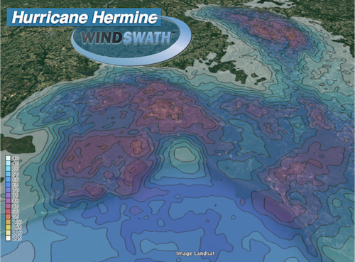
WindSWATH Map for Hurricane Hermine
September 2, 2016 - Tropical WeatherHurricane Hermine made landfall as a Category 1 hurricane during the early morning hours of September 2, 2016 in northwestern Florida around 1:30 AM EDT. Areas in and around Tallahassee, FL areas were clobbered with hurricane force winds in excess of 80 MPH with isolated pockets of 90+ MPH wind gusts. Hermine was the first landfalling hurricane to hit Florida since Hurricane Wilma in October 2005.
A detailed wind speed verification map of Hurricane is now available from AnythingWeather. Our WindSWATH report provides wind verification powered by a fully-automated, severe wind verification system from CoreLogic. This system combines proprietary, three-dimensional storm models with artificial intelligence, radar data, and real-world observations to analyze what actually happened.
 Buy Map Now
WindSWATH Features:
- View wind speeds from 40 MPH to 160 MPH
- 5 MPH contour levels
- Superimposed on Google Maps®